

Hi Guys,
I guess you know by now that I have moved to the Back Bay neighborhood in Boston. But, what you may not know is how Back Bay got its name.
If we look at a map of Boston today, we can see the neighborhood of Back Bay. The northern border is the mouth of the Charles River.
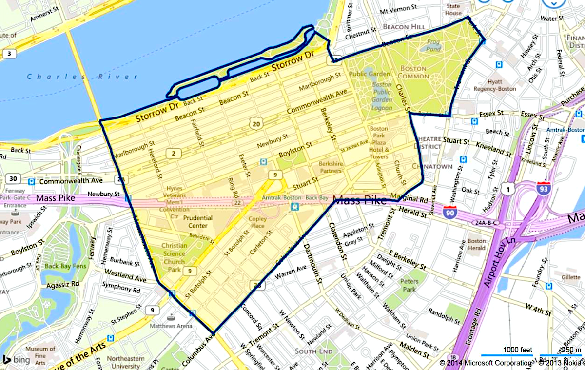
The residential areas are filled with historical brownstones. Walking around the streets is a dream come true.
However, back in 1630, when Boston was first settled, there was no land here; only water.
Indeed, I now live in the middle of what was once a body of water; a bay. To differentiate it from the larger bay to the east of the tiny Shawmut peninsula (Boston), they called it the back bay; the back bay of Boston Harbor. I mean Bahstan Hahbah. ;]
Even though the bay is now filled in with land (dirt), and yes, garbage, gravel, etc., it is still known as the Back Bay neighborhood of Boston.
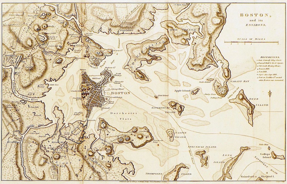
Above is a map of how Boston looked in 1630.
In fact, Boston grew from a tiny city of only 800 acres into what it is now, a large city 40 times that size. However, as large cities go, Boston is the second smallest in 48.4 square miles. The smallest town in terms of area is San Francisco, at 47 square miles.
What I find fascinating is that the school district I lived in, where my sons were raised, the Katonah-Lewisboro School District is 55 square miles. (see the blue dark blue area in the upper right corner of the map.) One school district! That’s just how to spread out the population is up in northern Westchester County in New York.
Of course, most large cities grow in size. That is if they have somewhere to grow.
So, how did this all come to pass?
A brief history.
Boston is a historical city and a keystone to the beginning of the American Revolution.
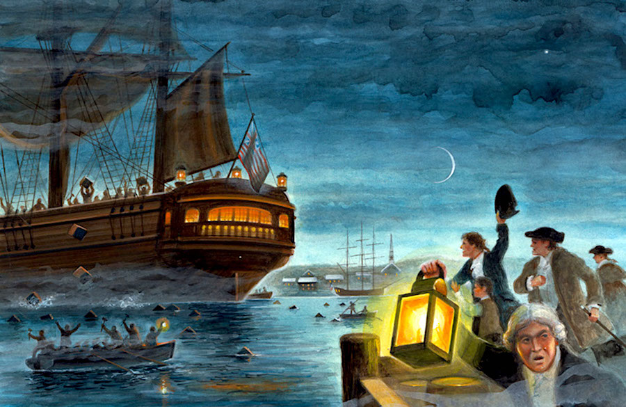
Boston, famous for its large natural harbor where incensed Americans dumped massive quantities of tea, had nowhere to grow. That is unless they created more land where there was currently water.
And, after the end of the American Revolution with the young country now separate from Great Britain’s rule, that is what began to happen in the early 1800s.
With the industrial revolution, ambitious Bostonians, coupled with commerce, and a burgeoning population, the well-heeled were running out of space to live.
And, so beginning in the early 1800s, Massachusetts’ capital city began creating land by creating dams and filling in the bay with thousands of acres of new land. They started with the pinhead Shawmut peninsula.
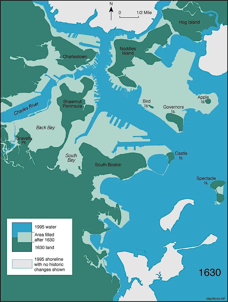
The above map shows the original city in 1630 in dark green. The light green areas are the filled-in parts.
The filling-in continued in the south end and then in the back bay, which wasn’t entirely filled in until 1900. My house was began construction in 1879 and it was finished in 1880.
Where did the land come from?
A lot of it was taken from the surrounding hills, such as Beacon Hill, which was far higher today. That land was used to create the western third of Beacon Hill known as “the Flat.” You may recall my photos from the flat and surrounding areas from about a month ago.
Below is an image I took while on a walk through Beacon Hill last week.
![]()
It doesn’t get any more classic than this Georgian-style beautiful red door with red brick. That definitely looks to be Benjamin Moore Heritage red. It’s the perfect “red door” red. For more beautiful front door colors, please check out this post.
Some of the dirt was brought in by rail cars from neighboring towns.
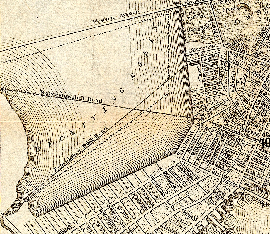
The above shows the Back Bay, which was also called the “receiving station.” But it became quite a cesspool and source of the stench. Can you imagine? It was believed that these foul smells lead to disease. And, in 1853, the filling in of Back Bay began.
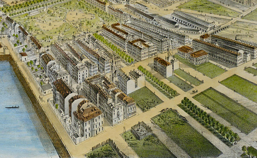
Above is a partial view of Back Bay beautifully rendered by F Fuchs in 1870. At the top of the drawing is the public garden. You can see the Commonwealth Ave Mall. My building is in an empty lot here.
I’ve done a lot of reading and will link to some exciting articles where you can see more maps, photos and read more about this fascinating history.
One thing that I’ve read repeatedly is that there are problems with the artificial landfill in terms of the water table.
Actually, the problems occur when the water table goes too low as the pilings that are the foundation for the land begin to rot. Conversely, the back bay is in a flood zone. It’s a complex issue as engineers are working for long-term solutions.
This is a superb blog post with some interesting info about the neck of the original Boston, which would be totally submerged during times of high tide!
I’m bringing down that map of old and new Boston, again. That huge swath of land above what was Governor’s island is where Logan International Airport is. That’s a lot of landfill.
I’m closing with one more excellent blog post I discovered.
An excellent short video sums everything up very nicely about creating Boston’s Back Bay.
Please note. There will be a quiz on Sunday.
No worries. It’ll be an open-book test. ;]
I hope you enjoyed learning a bit more about this beautiful city I’m living in and some of its rich but sometimes smelly history.
If you’d like to learn more about the houses of Back Bay, there is a fantastic blog called BackBayHouses. And, indeed, it chronicles every building on all 13 streets. The blog tells the history of each home from its inception to the end of the 20th century.
xo,

PS: Please check out the newly updated HOT SALES!
Related Posts
 The Most Exquisite Gardens and Landscaping Ever!
 Don’t Take Away Our Ceiling Fans – We Need Them!
 The Color Orange – Love it, or Hate it?
 I’m Afraid Our New Rustic Home Will Be Depressing!
 Impressive Decorating On A Shoestring Budget – Only 1,100.00 bucks!
 My Kitchen Light Fixtures Are Driving Me Bonkers
 Come See the Plans for My New Living Room Wainscoting!


28 Responses
Now that you have moved to Back Bay is your son now living in Brooklyn, NY? I thought you were moving closer to him?
Honey, when he told me last October I cried for six hours straight. However, it is a temporary move. His teaching job is in Springfield, MA
and he’s scheduled to have to show up in person beginning in April, so he has to come back. And, he’s coming to visit me president’s weekend for my birthday which is this weekend, but he has an extra day-off the following weekend.
I do understand where he’s coming from. It’s just that the timing sucks.
But, every summer, he has a gig in Boston for the month of July
as the music director of a day camp. If it’s normal this summer, he’s going to come and stay with me for the entire month!
I have never been to Boston, I’m from Russia, but I feel like I know it now. I have never thought that you could learn about history of the building through old maps. How cool is that! Super interesting to compare the Bay then and now. You’re amazing writer Laurel, thank you for the history lesson and for all the tips even with pronunciation. Wow! Now I’m wondering if you see water from your building windows and where is the best window view. Such an amazing architecture. Thank you for all the knowledge tips.
Love the maps as I am always lost in Boston and found NYC easier to navigate. Since you like architecture and history, don’t forget to visit the North Shore – Salem and Newburyport have beautiful historic homes and the Peabody Essex Museum is a gem.
Love it! This Southern girl would love to visit Boston one day!😁
Please do!
I used to live in Needham Heights. Which is a misnomer because there is no “height”. It was all sent to fill in just so you could live there! Before then I lived in your area. I do miss it.
Good job, you’re a virtuoso with the pictures and text.
Laurel- You get an A! LOL I’m so glad ( as your Realtor) that you have highlighted the history of how “The Back Bay” was filled. It’s quite mind-boggling that such an adventurous civic undertaking was completed in such a harmonious way. To follow up on more trivia- the design of the neighborhood was modeled on the boulevards of Paris. The grid of Back Bay runs East/West. I love the sense of order and symmetry. It was part of esteemed Frederick Law Olmstead’s plan to link it to the “Emerald Necklace” connecting the Public Garden to the Fens.
I love your links to backbayhouses.org which is such a fascinating read of who the families were who first inhabited these homes. What I find fascinating is that they all moved around to different homes in the neighborhoods! And to those who don’t live here the wooden “Pilings” or “columns” that hold all this rock and dirt and “stuff” together are kept in shape due to their being on water. Yup. We are under water here ( not floating mind you) and on many corners you can see a round hole on the sidewalk that allows engineers to take readings of the water table. How cool is that! More information on all of the land that is formerly bay or ocean can be found at the Boston Groundwater Trust. Thank you Laurel!
Thanks so much, Maureen for filling in all of that great information! For those reading comments. Maureen is indeed my fabulous and exceedingly knowledgeable realtor. I can’t recommend her highly enough if you’re looking to buy a home in Boston’s Back Bay, South End or Beacon Hill, I believe are her main areas. She made the entire process as easy as possible. Plus, she gently talked me down from the ceiling, lol when the mortgage company kept missing their deadlines! I can laugh about it now, but the prospect of defaulting and losing 65k was no laughing matter.
Another website you may enjoy is Mapjunction.com, which you can use to overlay historical maps of Boston from the 1630s to the present. Note that Boston Common was established in 1634, the nation’s first Common.
I went to school in Boston (BU) and loved walking in the Back Bay. Beautiful brownstones and gorgeous trees. Enjoy fully!! It’s an amazing city full of wonderful people. I loved going to open mike night at the Lenox hotel’s piano bar. It felt like stepping back in time. Not sure if they still have that but it was such a Boston thing to do! I have a close friend Rafi who lives in Cambridge that would be up for showing you around and doing something if you want an intro.
Welcome to Boston and all it’s history! If any of you are Historic Home geeks like me, two wonderful books are,
Houses of Boston’s Back Bay by Bainbridge Bunting (part of my History of Architecture curriculum at Design School) and
A Field Guide to American Houses by Virginia and Lee McAlester. This book is a great resource and so many of the examples of house styles are from Boston and Cambridge.
I am an expat to Boston from North Jersey (30 years now) so as usual, I know more about the history of houses in the area than most natives!
Thanks so much for the info, Barbara!
How interesting, loved it!
Thank you for doing this research for me. My grandson is at Emerson College and I cannot wait to visit him armed with such great information. My love affair with Boston began with your recent move.
Mary (Portland Oregon)
Good morning Laurel,
This is fascinating. I love learning the history of different parts of our country. I guess I need to schedule some time today to read the links you’ve included.
Thank you for doing the research.
Wow! That’s completely fascinating. I had no idea!
Hi Lauren
This is a fascinating history of one of the USA’s most historical cities. I was there once, oh, about 40 years ago with my parents. Id love to visit again. (I’m in Ontario Canada). A lot of London is also built on “garbage”.
I’d like to visit the blog on the history of Back Bay houses, but the link appears to be broken
The other links work though.
Thank you!
Oh dear. Thanks for telling me about the broken link. I fixed it. It’s an amazing website!
Enjoyed the video, my daughter lives in Weston another beautiful town in Mass. I know you will be happy living in such a beautiful city, rich in culture.
Thank you for the excellent history. Boston is a city near and dear to my heart and I never tire of reading how people describe their interests and experiences in the city. I am always encouraged when someone takes the time to learn about an area new to themselves for this knowledge enhances ones engagement with the community. My very best wishes to you in your new home and in your new city. I’m certain that you will continue to learn wonderful and interesting pieces of Boston’s rich history and culture.
Scarlet darling
That was my next question
What the heck about flooding
great history lesson, especially the map of then and now. thanks for including that and the other maps. I had a friend who lived at Trinity Place near the BPL and it was fun to see it in relation to the rest of Boston.
I used to live in Back Bay – on Beacon and also on Gloucester – and walked to work on Newbury. I still love the area. And I adored the alleys! Your blog posts have brought back so many happy memories. Your new place is stunning and I can’t wait to hear more. Good work on finding an ideal new home!
Hi Shelby,
I face an alley. On my side of the street, it’s either north-facing or south-facing alley. I was concerned that it might be noisy. But, these houses are so solid, that a truck can go past and I won’t hear it!
The history of Boston and Back Bay Boston has been my entertainment of the night. Your blog has been so interesting and informative. I’m now going to read the blog about the Back Bay Houses. I had no idea so much fill was brought in to create more land area. I live in New Orleans on the south shore of Lake Pontchatrain. After WWII the south shore of the lake was blocked off and soil was brought in to create new subdivisions along the shore of the lake. Thank you so much for all of the most interesting Boston history.
That’s so interesting!, I didn’t know this. Humans really are so ingenious. Seattle has a large area of town built on landfill and Mexico City is a huge city built on baskets of dirt. It’s so outlandish to ponder this.